First Peoples' Map Help Documentation
WELCOME!
To the First Peoples' Map of B.C. (located at maps.fpcc.ca). Use the Quick Links below to learn basic and advanced features of the map!
Have questions? See our FAQ's!
Find an Article:
Quick Links
Exploring the First Peoples' Map of B.C.
Navigating the Map
Anyone can view the First Peoples’ Map – there’s no need to login! Just visit maps.fpcc.ca to browse our public collection of language, arts, and heritage sites.
The interactive First Peoples' Map of B.C. has four main areas:
The main map
The information sidebar (left)
Search and user elements (top middle/right)
Navigation and interaction elements (bottom middle/right)
To view help documents and find information about the map itself, click the "Menu" button at the top right corner of the map for options.
Browse, Search, Filter Groups & Features
Use the sidebar to explore map points and areas in the current map area.
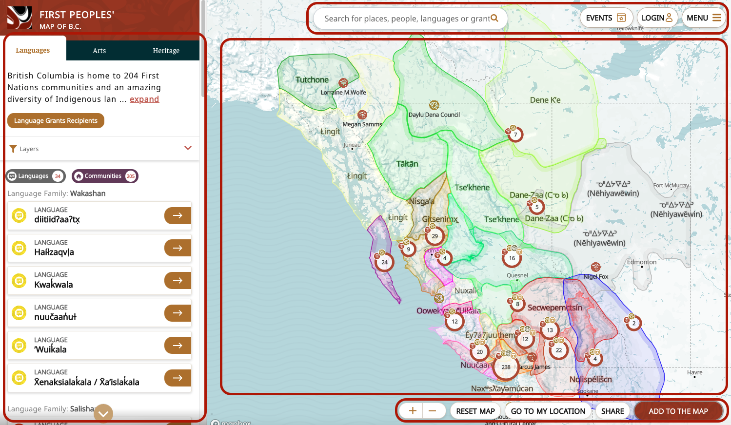
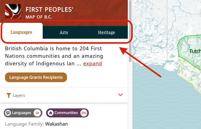
Select a tab at the top of the sidebar to focus on Languages (and communities), Arts (artists, public art, organizations), or Heritage (points of interest).
Under each tab, map points are listed under specific categories.
Under the "Languages" tab, you can filter for a list of Languages or Communities. For example, clicking on the "Communities" category will show only community points in the sidebar.
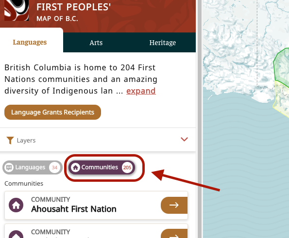
Under the "Arts" tab, you can filter points in the categories of Art, Artist, Public Art, Events, or Organizations. You can also choose sub-categories such as carvers, textile art, government organizations, or museums.
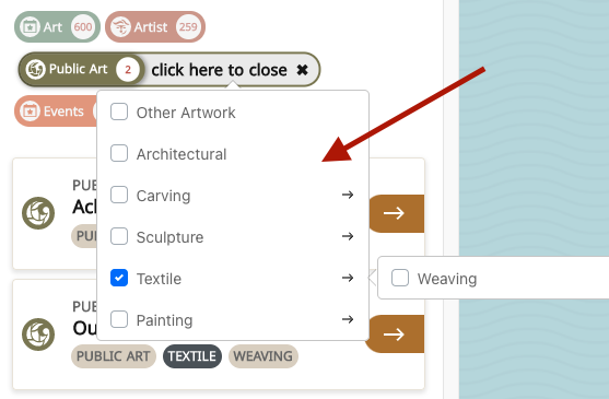
Example:
To get a list of all public carving art pieces, follow these steps:
- Load the map at maps.fpcc.ca.
- Click on the "Arts" tab in the sidebar.
- Click on the "Public Art" category button.
- Click on the "choose a sub-category" area of the button.
- Select "Carving" from the checklist, then close the sub-category selector ("click here to close").
- View the results in the sidebar; click on any result to view it on the map and see details.
Browse Features Geographically
Use the buttons at the bottom of the map to zoom in and out, reset the map to view the whole province, or focus on your current location (if your browser has access to location settings). You can also zoom in and out by scrolling your mouse.
Click and drag the map to move it around. Click on any labeled area or point to move there and zoom in.
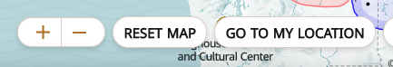
Click on a language area or point on the map to zoom the map onto that element. Clicking on grouped points will zoom the map closer so you can see more of them!
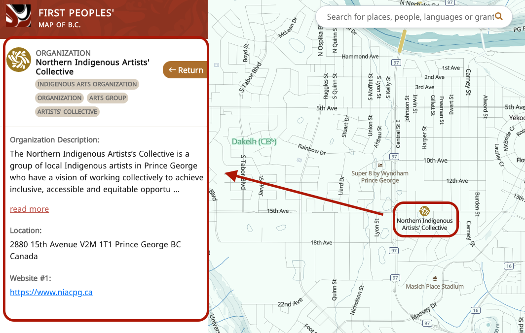
Check the sidebar to see detailed information about a feature you’ve clicked on. Browse the map to find different points that represent communities, organizations, arts, and heritage sites, and click on them to view information, images, and descriptions related to those sites.
Search for Specific Features
Looking for something or someone specific?
How to search:
- Click the search bar at the top middle area of the map.
- Start typing your search term. The list will update with results as you type.
- Scroll through the list of results to find what you are looking for.
- Click any result to zoom in on the point in the map.
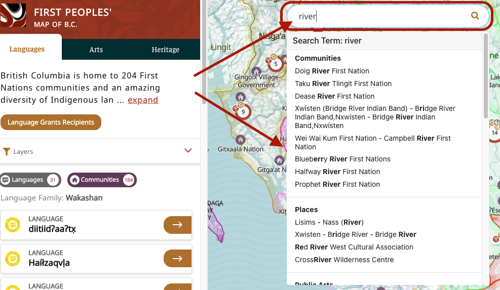
Search results will be sorted by category to help you see what kind of point it is, including:
- Languages
- Communities
- Organizations
- Artists
- Arts / Public Arts
- Places / Points of Interest
Below these results, you’ll also see Locations and Addresses provided from the B.C. Geographical Names Database and other public geographic repositories.
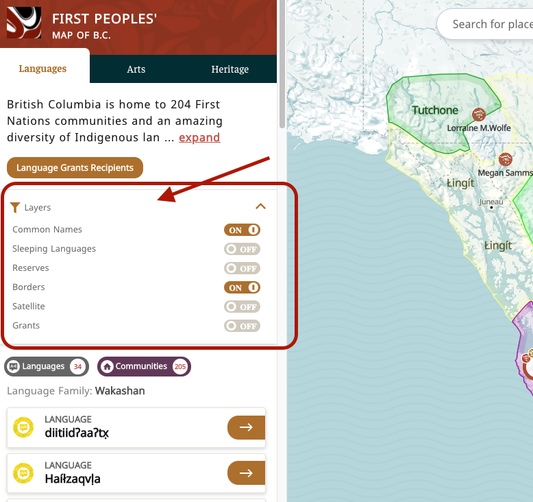
Customizable Map Layers
Click the "Layers" strip in the sidebar. This will open a list of options to customize how the base of the map looks.
You can toggle on any of these layers to show them on the map:
- Common names of cities and geographic features
- Coloured areas for sleeping languages
- Location and names of reserves
- Borders of countries and provinces
- Satellite background for the map
- Icons and map points for FPCC grant recipients
Additional Map Features
Follow a Language or Community
- Login to the map.
- Click on a language or community.
- Click the “Follow this Language/Community” button on the sidebar to follow and receive notifications about that language or community.
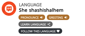
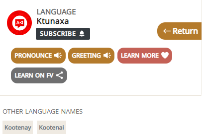
Language-learning Resources
- Click on a language.
- Click the "Learn More" banner in the sidebar to view detailed statistics and see links for learning/informational resources.
or:
- Click on the "Learn on FV" button in the sidebar to go to FirstVoices and see the community language site for that language.
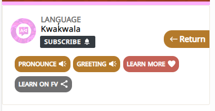
Indigenous Language Pronunciations
- Click on a language, community, or point of interest.
- Click on the "Pronounce" button in the sidebar to play an audio recording associated with the name, where available.
- (For Languages) Click on the "Greeting" button to hear a greeting in that language.
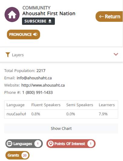
Community-learning Resources and Pronunciations
- Click on a community.
- Click on the "Pronounce" button in the sidebar to play an audio recording associated with the name, where available.
- View the sidebar to learn more about:
- community information
- speakers within the community
- how many and which languages are spoken
- points of interest
- how many grants this community has received
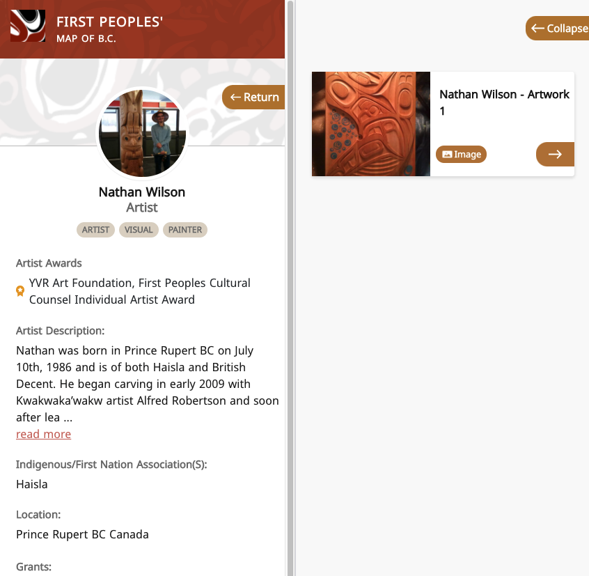
View Artist Portfolios
- Click on an artist's profile.
- An extra sidebar will appear with all art pieces they have uploaded (audio, image, or video).
Key of Icons & Map Points
On the First Peoples' Map, you will find various markers placed around to mark communities, art, and various points of interest. Each one is flagged with an icon to let you know what kind of point it is.
Icon | Point Type | Information |
|---|---|---|
| Language area | The coloured areas and labels represent a language area, loosely indicating the geographic areas where Indigenous languages were traditionally spoken. Click on the area to view a greeting, pronunciation help, links to learning resources, statistics on speakers and learners, and a full list of all other points in the language area. |
| Community | This represents an Indigenous community. Click on it to view contact information, language(s) spoken, pronunciation help, and statistics on numbers of speakers and learners (where available). You can also view the history of FPCC grants associated with the community. |
| Organization, cultural centre | This represents an Indigenous organization or cultural centre. Click on it to view a description, website, and/or access information. |
| Artist | This represents an Indigenous artist. Click on it to view further information about the artist, as well as a portfolio of art pieces they have uploaded or connected to their profile. |
| Public Art | This represents a site of Indigenous public art. Click on it to view a description and/or images of the site. |
| Point of interest | This represents a point of interest or heritage site. Click on it to view a description and/or pronunciation information. |
| Event | This represents an event. Click on it to view a description and any images associated with the event. |
| Grouped point | This is a grouped point that includes several points at the same or similar location. The different types of points at that location are indicated with small icons. Clicking on the point will zoom you into the group. If several points are located in exactly the same place, clicking the grouped point will bring up a list. |


Getting Involved
The great, unique feature about the First Peoples' Map is that Indigenous artists, language champions, Elders, and Knowledge Keepers are able to put themselves and their own content on the map. This means they can maintain control over the information that is shared and manage how they would like to be represented. We encourage Indigenous artists to create profiles on the map in order to upload their portfolios or other works of art that they wish to share.
First Steps
First, you must create an account if you wish to add any content or data to the map. Next, you will need to Login to the Map and manage your Personal Profile.
Checklist Before Adding Content to the Map
All arts and cultural points on the First Peoples' Map are user-contributed. Whether you are adding your own content or submitting publicly available information, we suggest you run through the following checklist before you submit a new point or correction to make sure that the map is accurate and that Indigenous communities and artists retain control over their publicly shared information.
Checklist for Uploading Map Content
- Have you verified that the names and information are correct?
- Have you checked with your community/the originating community that the information is appropriate to upload?
- Have you verified that the address is correct, and that it is appropriate to upload the exact address (where applicable)?
- When uploading images, do you or the original creator have the rights to the image?
Once you are sure you have accurate information that is appropriate to share on the map, we welcome you to add the content to the First Peoples' Map.
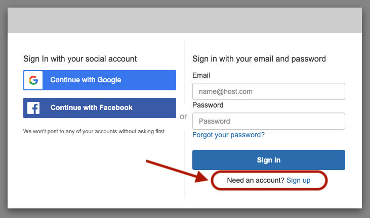
Create an Account
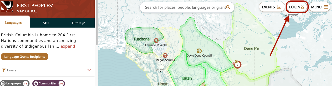
Click “Login” at the top of the map page.
Click “Sign up” and complete all fields (email, name, password).
Next, you will receive a verification email. You must verify your email before you can continue.
Once verified, your registration will be confirmed! Click “Continue” to be redirected to the map.
Now that you’ve successfully signed up, go ahead and login to the map to create your user profile!
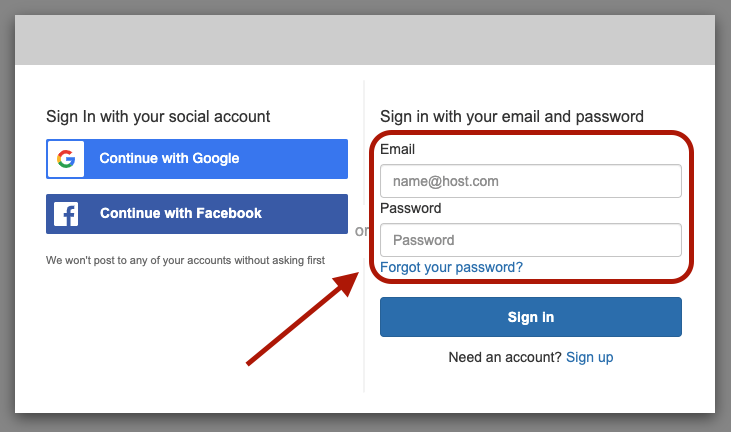
Login to the Map
Click “Login” at the top of the map page.
Enter your email and password, and click "Sign In" to continue.
Tip
The First Peoples' Map is separate from other FPCC platforms. Make sure you have created a username and password for the First Peoples' Map, and are using the correct password – make sure you are not accidentally using the password you created for your FirstVoices account or the FPCC Grant Portal!
Managing Your Personal Profile
Once you’ve registered for an account and logged in, you can create a personal profile for your account. This profile information will not be visible on the map. It is only for personal user account details.
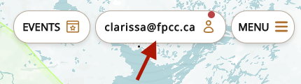
- Click on your username at the top right
- In the sidebar, click the "Edit" button under your profile image
- Add information about yourself to the fields
- Image: a profile picture
- Name
- Language: your heritage language(s), if applicable (you can add more than one)
- Community: Indigenous community(s) you are associated with, if applicable (you can add more than one)
- User Description: any other information about yourself.
Once your account profile is complete, you are ready to start adding your own content!
Add New Indigenous Content to the First Peoples' Map
Begin adding new content to the First Peoples' Map by clicking the 'Add to the Map' button on the bottom right corner of the map.
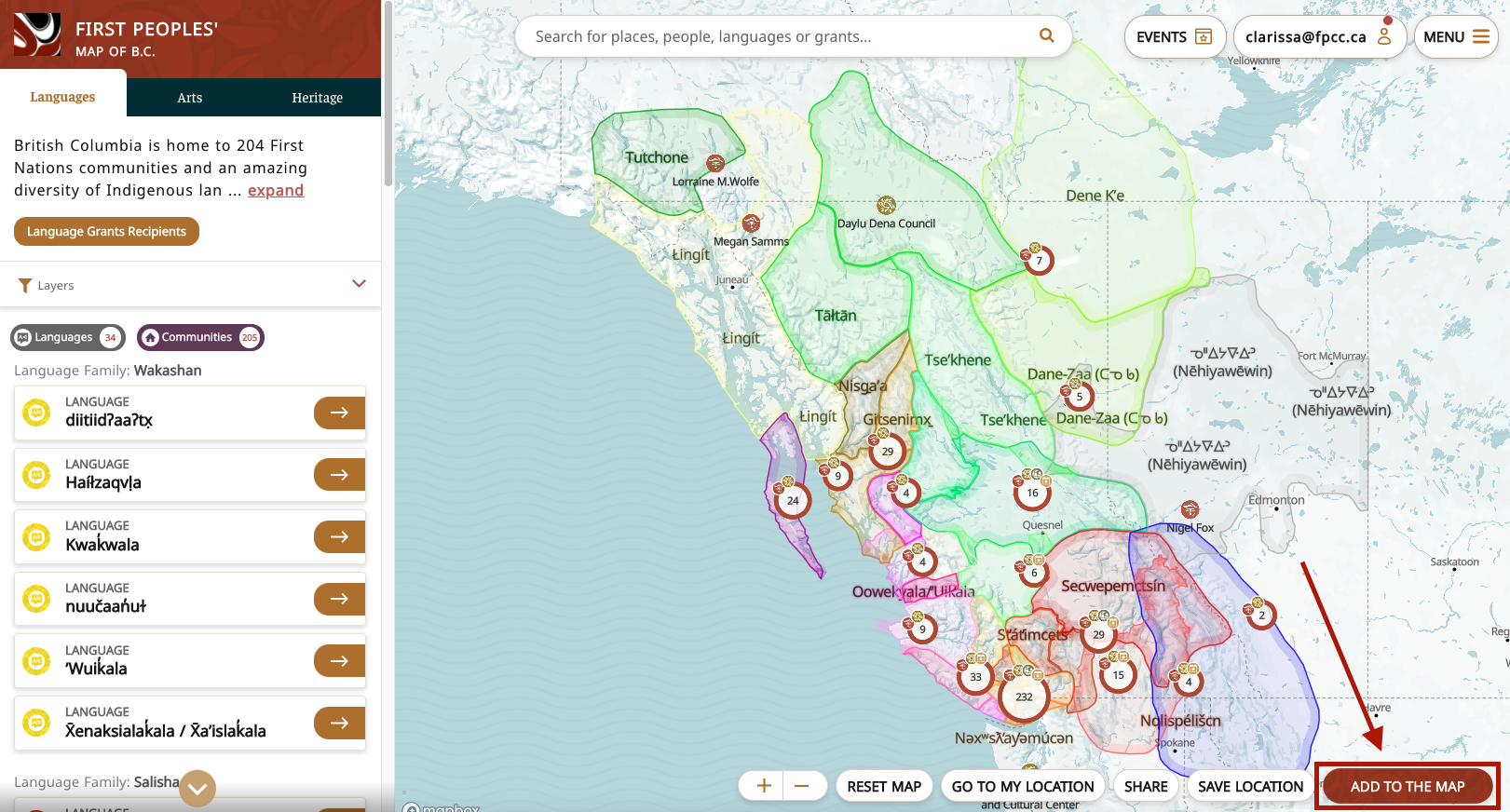
Select the type of data that you would like to add and follow the prompts.
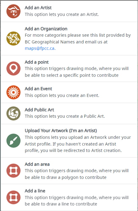
See some examples below!
Create your own Indigenous artist profile
- Click your username in the top right corner of the map
- In the sidebar on the left, find the box to create your own artist profile and click it
- Add a pinpoint to the map to indicate a location where you are currently residing. Exact address is not mandatory.
- Complete the artist profile information in the sidebar on the left: image, artist name, language, community, discipline, location, awards, website, bio, artist statement, etc. This will help users get to know a little more about you as an artist.
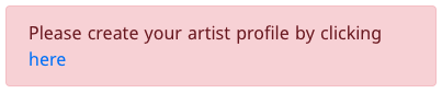
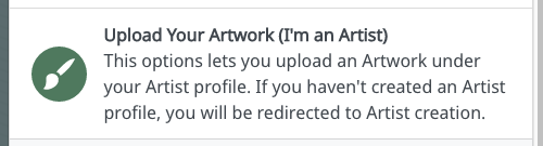
Add your art to your Indigenous artist portfolio
- Click "Add to the Map" in the bottom right corner of the map
- Select "Upload Your Artwork (I'm an Artist)" from the menu
- Fill out the information form in the sidebar on the left, and upload a media file (image, audio, or video) for your artwork. It will be searchable on the map and visible from your artist profile.
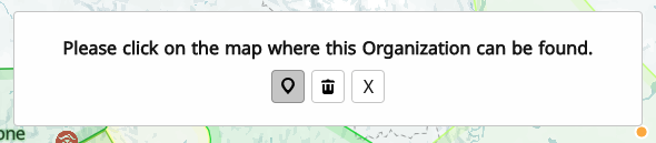
Add your Indigenous organization or landmark
- Click "Add to the Map" in the bottom right corner of the map
- Choose what kind of Indigenous landmark you would like to add by clicking the appropriate option in the menu that appears
- Click "Add an organization" for an Indigenous organization
- Click "Add public art" for a site of Indigenous public art
- Click "Add an event" for an Indigenous event
- Add a pinpoint to the map to indicate a single location where your site can be found. You can zoom in to the map so you can add it at a precise location. An exact address is preferred.
- Complete the organization profile information in the sidebar on the left. Upload an image, and provide the name, location, email, website, description, etc. This will help users get to know a little more about you as an organization, or about the site or event.
- You can share more about your organization by clicking “upload a media/file” (image, audio, video, YouTube link) that will be visible from the organization profile
Add traditional place names and local heritage sites
- Click "Add to the Map" in the bottom right corner of the map
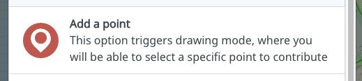
- Click "Add a point" to add a point of interest. (Or you can click "Add a line" or "Add an area" to draw.) You can zoom in to the map in order to add the feature at a precise location.
- Fill out the information about the point in the sidebar on the left: include a name, image, taxonomy (type of point), location, description, etc. This will help users get to know the site or the meaning of the name.
- You share recordings of pronunciation or videos by clicking "Upload a media/file"
Editing Existing Points or Boundaries
Any user who adds points to the map can edit those points later.
To edit a point you added:
- Select the point on the map that you want to edit
- In the sidebar on the left, click the “Edit” button
- Edit any of the point details
- To change the location or geometry of a point, interact with the map below where it says: “You may draw new geometry to replace the existing one.” Click on the existing point balloon and then click where you want the new point to be.
- To change any of the description or properties, edit the text or media fields in the sidebar on the left
- When you're finished, go back to the sidebar on the left, scroll to the bottom and click “Update”
You can only edit points that you have added – you can't edit points that were added by another user. If you notice an incorrect point that you cannot edit:
- Try to flag the correction with the originating community or creator.
- If you're not sure who that is, then contact us at maps@fpcc.ca to flag the suggested edit.
Using or Sharing the First Peoples' Map
Order Paper Copies
Love the First Peoples' Map? We're happy to provide physical copies on request. View our price list for print copies and submit it to maps@fpcc.ca.
Order Digital Copies
To receive digital copies of the map (pdf, image), contact us at maps@fpcc.ca. We have small and large sizes available. Always acknowledge the First Peoples' Map when reproducing digital copies of the map.
Share or Embed the Map on a Website
How to get an embeddable version of the map:
- Click the "Share" button at the bottom right of the map
- Copy the sharing details. You have two options:
- Copy the link to the map. The link will take anyone who follows it to the current view on your screen.
- Copy the embedded iframe code, and paste it into your website code. The embedded view of the map will mirror the current view on your screen.
- Make sure you acknowledge the First Peoples' Cultural Council and First Peoples' Map of B.C. where you share the map. Link back to us!
Develop With the Map API
We allow access to the First Peoples' Map API for individuals and organizations producing non-profit, educational map applications, in compliance with our Terms of Use.
- Submit a description of the proposed API use to maps@fpcc.ca
- The First Peoples' Map Team will review your request and get back to you
About the First Peoples' Cultural Council
The First Peoples’ Cultural Council (FPCC) is a provincial Crown Corporation formed by the government of British Columbia in 1990 to administer the First Peoples’ Heritage, Language and Culture Program. The mandate of FPCC is to assist B.C. First Nations in their efforts to revitalize their languages, arts and cultures. For more information, please visit our website: www.fpcc.ca.
Language Map Project History
The First Peoples’ Map of B.C. originated as the First Peoples’ Language Map of British Columbia and was initiated by First Peoples’ Heritage, Language and Culture Council (FPHLCC, commonly First Peoples’ Culture Council - FPCC) in 2005 with funding from the BC Ministry of Education.
The language map was started by linguist Sarah Kell with contemporary language group boundaries provided by the Museum of Anthropology at the University of British Columbia. Adjustments were made to the language group boundaries based on First Nation reserve locations and best available knowledge of language spoken by First Nations affiliated with reserve lands. Historical information on territories of sleeping languages was prepared for the Handbook of North American Indians (1996, revised 1999) under the supervision of Dr. Ives Goddard and is reproduced with permission of the Smithsonian Institution. Additional map data was added from a number of sources. (See Map Data Sources). The first online map was created by Global CADD Systems.
In 2008, Alex Wadsworth and Towagh Behr led the expansion of the online map into a website with content on the languages, First Nations and community champions. The development of the web-based Drupal content management system was completed by Patrick Hayes of GeoMemes. To build content for the website, Towagh completed a short series of interviews with fluent speakers from around the province. Alex, Towagh and Patrick also turned the FPHLCC Language Status Assessments into online surveys that continue to populate the website with current statistics on language fluency and learning. In 2014, Alex Wadsworth worked with Greg Sebastian and Dr. Charles Burnett of GeoMemes to update the whole system, upgrading the maps to Leaflet library and making refinements to the Language Status Assessment surveys.
In 2019, FPCC contracted Countable Web Productions to modernize the map and create a system that includes diverse data points (language, arts, heritage). The new version you are seeing today includes support for user contributions as well as an improved user-interface with better mobile compatibility and new data points.
Arts Map Project History
The original First Peoples’ Arts Map was shaped by a number of forces combined with a series of cultural mapping gatherings organized by the First Peoples’ Cultural Council’s Arts Department in 2005, 2007 and 2009. In 2005, First Peoples’ Cultural Council’s then Arts Program Manager, Cathi Charles Wherry wanted to more effectively and creatively gather and illustrate some of the energy, intelligence, strength and richness that Indigenous artists and cultural workers consistently brought to our work together when we gathered. This was related to a conscious desire to focus on the positive, Indigenous artists’ strengths, the resources they draw on, what’s working, and how we frame and define ‘success’.
At the same time, Cathi was introduced to the potential of cultural mapping processes when she met international cultural consultant Robert Palmer at a think tank in 2005. This meeting coincided with her planning of the FPCC-hosted 2005 National Aboriginal Arts Administrator Gathering. Robert Palmer guided and worked with her to develop a facilitation plan that would introduce the group to cultural mapping during the 3-day event. 30 Indigenous arts leaders from across the country participated in the gathering, which was inspiring, energizing and a great success. Through creative exercises the group explored relationships, resources and forces that impact the work they do. We also had fun!
One of the exercises at that 2005 gathering sparked the idea to organize a similar B.C focused cultural mapping session. After fundraising and planning, in 2007 FPCC convened 30 Indigenous artists, arts administrators and community leaders from across B.C. Again, Robert Palmer provided guidance through developing a plan for cultural mapping facilitation and appreciative exploration exercises. The group visualized significant aspects of their arts ecosystems, such as:
Artists’ relationships to community, history, place, and other artists and organizations
Resources crucial to artistic vitality, such as materials from the land, mentors, studios, galleries, events, financial resources, and
Forces that influence the success of their work, including collaboration, sense of community, connections to history and spirit, and meeting with like-minded people.
All of these explorations were inspired by and graphically illustrated through creative exercises, allowing people to identify patterns and clear connections, and to see how they fit into this network of relationships and forces. This is when the idea of an online Indigenous arts map emerged.
In 2009 another B.C. Cultural Mapping Gathering was organized. Facilitation consultant Paula Beltgens provided guidance with a facilitation plan that strategically led to solid input for the creation of a living online Indigenous arts map. The results were analyzed and workshopped by Arts staff, members of the facilitation team and map developers Geomemes. As a group we developed the complex schema for the first arts map, which was built to be interactive and automated. Launched in 2012, the First Peoples’ Arts Map has grown to provide an online space where Indigenous artists, groups and organizations can put themselves on the map and gain visibility for their practices as visual artists, performers, musicians, storytellers, and media artists, in the context of each other’s work.
The map has been improved over time. During 2020 this current iteration has been further updated, modernized, and merged with language and heritage on the First Peoples’ Map of B.C. with developers, Countable Web Productions. However, it remains rooted to Indigenous arts communities who contribute all of the content. We hold our hands up and say miigwech to everyone who participated in or supported this work leading up to the creation of the original First Peoples’ Arts Map. This is the foundation of what is now the Arts facet of the new First Peoples’ Map of B.C.
Map Data Sources
Living Language Group Boundaries Initially based on a map provided by the Museum of Anthropology at the University of British Columbia, and reproduced with permission.
Sleeping Languages and Historical Language Group Boundaries Based on a map prepared for the Handbook of North American Indians (1996, revised 1999) under the supervision of Dr. Ives Goddard, and reproduced with permission of the Smithsonian Institution.
Language and Dialect Names based on research by the First Peoples’ Heritage, Language, and Culture Council
Reserves ©2003 Government of Canada, reproduced with permission from Natural Resources Canada.
Band Office locations Prepared by Public Works and Government Services Canada for Indian and Northern Affairs Canada, and reproduced with permission.
Sites of Interest Based on research by the First Peoples’ Heritage, Language, and Culture Council
Coastline, islands, lakes, rivers, roads, railways, background land layers Provided by the BC Ministry of Energy, Mines, and Petroleum Resources
BC Communities BC Digital Gazeteer, provided by the BC Integrated Land Management Bureau
Provincial Boundaries, National and Provincial Parks © Government of Canada
State Boundaries Provided by the US Census Bureau
Frequently Asked Questions
- How do I create an account for the FPCC Map?
- How can I add myself as an Artist to the FPCC Map?
- How can I add information to the Map relating to my community?
- How can I find language or community pronunciations?
- Where do the Map points come from?
- How can I order a paper copy of the Map?
- Can I use or embed the Map on my own website?
Need more help?
Can't find answers to your questions here? Try this:
- Send a message to the Maps team at maps@fpcc.ca
- Email the FPCC/FirstVoices Support team at support@fpcc.ca